
LAKEVIEW, Ohio (WLIO) - The Ohio Department of Natural Resources unveils a new historical marker at Indian Lake State Park.
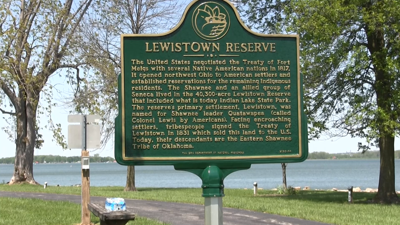
The marker pays tribute to local history and a pair of treaties with Native American tribes: the Treaty of Fort Meigs, which paved the way for the settlement of Northwest Ohio, and the 1831 Treaty of Lewistown, which purchased the land where Indian Lake is located from the Shawnee and Seneca tribes. The marker is located on Paradise Island at the eastern edge of the lake front walking trail. Mostly hand dug, the original reservoir wasn't designed for recreation, but to provide a consistent water flow to the Miami and Erie Canal.

The marker pays tribute to local history and a pair of treaties with Native American tribes.
"This was made for the Miami and Erie Canal; there were two reservoirs just north of here - Lake Loramie and Grand Lake St Mary's - and this was to help for a little bit south to keep water levels constant," said Neil Humphrey, a historian with ODNR. "During the summer, some canals would dry up, and during the winters they might freeze, so they didn't have enough water flowing through. They needed three to four feet of water constant throughout the year."
Humphrey says even while the reservoirs like Indian Lake were being used as canal feeders, they attracted sportsmen and once they no longer served the canals, it appeared they were still popular.
"By the late 1800s these things are sitting around, the state takes possession of them in the 1870s, [and they found that] a lot of people like to recreate on these, so they were turned into these recreational reservoirs - first at Buckeye Lake in 1893, and Indian Lake was the second one in 1898. These are the really earliest kind of hints we can get for our current state park system."
For all the latest events taking place at the Indian Lake State Park, you can check out their Facebook page.


