

A quieter weather week ahead with no "major" storms showing up over the next 7-10 days. Instead, a series of weak waves from the northwest will keep our skies more cloudy than sunny this week, and flurries will fly at times.
After some sunshine to start our Monday, a deck of clouds will spread in from west to east during the day. Temperatures are expected to remain rather steady in the upper 20s. A few spits of flurries or drizzle cannot be ruled out later today (mainly north), but this activity will be minimal.
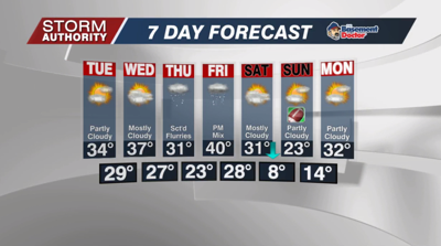
Tuesday morning will be the coldest of the work week with teens and a few single digits. Clouds are expected to break up for some sunshine, especially by the afternoon. Temperatures will rebound nicely to the lower and middle 30s with a southwest wind up to 15mph.
Temperatures won't be too shabby midweek. Wednesday morning starts much warmer in the upper 20s and low 30s. Highs will reach the upper 30s under cloudy skies.
Scattered snow flurries are expected to fly Wednesday night and Thursday. Thursday will be colder with highs staying just below freezing. A stronger clipper system is expected to dive into the Great Lakes Friday. This will bring a band of rain and snow later in the day. Temperatures could reach 40°, but it looks to turn much colder for the weekend with highs below freezing.


