

A strong storm system continues to unleash strong winds and create big temperature extremes in our area. Wednesday's temperature topped out at a warm 75°, our warmest day since October 15th. The winds became very strong overnight with several gusts topping 50mph - peaking at 56mph. The wind stays gusty today as temperatures crash into the 40s. Wind alerts from the National Weather Service are set to fully expire by 2pm as gusts taper closer to 30mph by late afternoon.
Additional scattered showers will arrive toward the evening. Some snow will mix in closer to midnight into Friday morning. Temperatures will drop to near and slightly above freezing by daybreak.
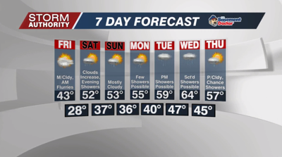
Friday is a chilly day with clouds winning the battle. A few flurries could fly in the morning, but overall a dry day is expected. Clouds will tend to clear toward sunset with highs in the lower 40s. Expect more tolerable winds at 10 to 20 mph. Lows then fall to the upper 20s with mostly clear skies Friday night.
The good news is highs should bounce back up to the lower 50s this weekend with light winds. Some sunshine Saturday morning gives way to clouds by the afternoon. A disturbance brings light rain to the area Saturday evening - generally after 5PM through midnight. Sunday looks dry with mostly cloudy skies.
Next week is an active week with shower chances each and every day. No particular day looks like a washout as the showers will tend to come in waves. Highs will run close to average through Thursday.
