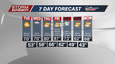

Monday, May 16, 2022: A cold front delivered widespread rain overnight, but sunshine returns today as a cooler and drier air mass arrives. Highs in the lower half of the 70s can be expected with partly sunny skies. A stray, random shower could pop-up this afternoon, but in general expect sunshine to dominate. A breezy northwest wind could gust up to 25mph at times during the afternoon.
It will be a fantastic Monday evening for any outdoor plans, and we'll enjoy mainly clear skies and pleasant weather overnight. Expect a low around 51° for Lima by daybreak Tuesday.
Tuesday is probably the pick of the week with mostly sunny skies, a light breeze, cool temperatures and low humidity. Highs around 70°.
Clouds return Wednesday as our next disturbance brings the threat for scattered showers. This will not be an all day event. A thunderstorm could mix in, but it appears severe weather will stay well south of our area.
Data has trended toward a dry and warm day Thursday with partly cloudy skies. Highs will return to around 80°. We could see a few storms lift in from the south Thursday night.
Friday looks unseasonably hot and very windy with highs well into the 80s, if not close to 90. This is all ahead of a front producing a strong clashing of air masses over the central U.S. We are favoring a mainly dry day with the main storm chance arriving with the cold front late in the day or possibly not until Saturday. There is a huge spread regarding the placement and timing of this front, so we cannot say exactly when that best storm threat arrives. This also leaves a lot of wiggle room for forecast changes on Saturday (slower front = 80s and storms, faster front = 60s and decreasing rain). We do have increasing confidence in drier and sharply cooler weather by Sunday and Monday. We may see a 25° drop in highs by Sunday with highs in the lower 60s, and possibly lower 40s toward next Monday morning.


