

A wintry start to April with scattered snow showers to start the day. These flurries and snow showers will move out this afternoon with mainly cloudy and chilly weather. Highs will top out in the lower 40s. A northwest wind will gust to 20-25 mph, further adding to the chill.
A high pressure system gives us clear skies tonight and allows winds to go nearly calm. Lows will drop to the upper 20s.
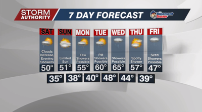
Sunshine to start Saturday will get replaced by clouds rather quickly during the day. A weak storm system will spread light showers into the area by evening, mainly after 5PM to around midnight. Rain totals around a tenth of an inch are possible. Expect highs tomorrow around 50°.
Sunday looks dry with mostly cloudy skies. Highs should reach the lower 50s.
A fast moving disturbance will bring a few showers on Monday, especially during the morning hours. Our next system will move up from the southwest later Tuesday into Wednesday, giving us another round of showers. Wednesday through Friday, an upper-level low will dive in from the northwest with origins from Canada. This keeps a daily shower threat along with a blast of colder temperatures for the end of next week into next weekend. Once we finally get rid of this pesky system, a more sustainable stretch of mild days (60s & 70s) may arrive for the following week.
