

After a week filled with gorgeous summer weather, we have rain chances to discuss over the next several days as muggy weather makes a return. This blog will breakdown what to expect as you plan out your weekend!
TODAY THROUGH TONIGHT:
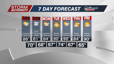
A sunny start will give way to a gradual increase in clouds. A system will approach from the west and bring shower chances by the evening hours, mainly after 6PM. This rain should end up rather scattered and light for the evening as it runs into a drier air mass locally. Slightly better chances deeper into the overnight and early Saturday morning. Highs reach the middle 80s this afternoon and fall to the upper 60s tonight.
SATURDAY:
Thinking is much of the day will be dry. Becoming very muggy and quite warm. We could see some lingering showers at sunrise, but we'll see some partial clearing of the skies and lower rain chances as the morning wears on. Expect a partly cloudy afternoon with only an isolated rain threat...lots of dry weather for the outdoor events going on. Highs in the middle 80s.
SATURDAY NIGHT-SUNDAY NIGHT:
Only isolated rain chances Saturday evening, then those chances increase to scattered showers after midnight, with scattered showers and storms very likely for Sunday. We'll have to watch for pockets of slow-moving downpours that could dump plenty of rain in a short time. This will be a situation where rain amounts will vary widely from one spot to another, but many will see rain occur at some point on Sunday. While a stray stronger storm cannot be ruled out, the overall severe weather risk looks low throughout the weekend.
Rain chances become widely scattered to isolated Monday. After that, a dry pattern for much of next week. Hot and humid weather, outside of a brief relax in the heat next Thursday.


