


A blast of true summer-like weather moved over the area this weekend, pushing area temperatures as high as the middle and upper 80s. A cold front is crossing the area today with off and on showers. A long stretch of below normal temperatures will follow.
Off and on showers will continue through late afternoon across the area. A couple thunderstorms could mix in, but any strong or severe storms should generally stay outside of our area, closer to central Ohio. Most of the showers will wrap up by 5PM.
Expect a chilly night as conditions dry out. Lows drop in the upper 30s to around 40°.
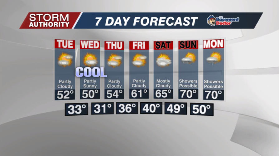
Tuesday looks dry and quite cool. Skies will vary between partly and mostly cloudy with highs in the lower 50s.
A "blocking" weather pattern will keep a cool and mainly dry forecast in place for multiple days. The cool weather peaks on Wednesday with highs ranging from the upper 40s to lower 50s, but the sunshine will make things feel better. Frost is likely Tuesday and Wednesday night. If clouds stay away, some spots could go below freezing Wednesday night. Temperatures start to rebound in the middle 50s Thursday afternoon.
Seasonable temperatures return by the weekend with highs in the 60s. Highs closer to 70 are expected by Sunday and Monday. Models are at odds regarding when our next rain threat picks up. For now, it seems like the best chances hold off until Saturday night and remain off and on into next week.


