

Be sure to grab a rain coat today. Light showers will overspread the area by mid-morning, with off and on shower activity this afternoon. Expect cooler highs in the 50s.
Expect steady temperatures in the 50s tonight as winds become gusty at times from the southeast. Showers will continue off and on through the night.
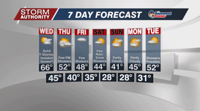
Expect scattered showers Wednesday morning. As we reach toward midday into the afternoon, some sunshine will break out in between showers. That will create enough instability for scattered thunderstorms to break out during peak heating, mainly 2pm to 7pm. A severe storm or two will be possible. This is more of a conditional severe threat as it really depends on whether sunshine breaks out. If thicker clouds hold and rain is more widespread, severe storms will be unlikely. If a severe storm develops, threats include hail, gusty winds, and a brief spin-up tornado. Highs will top out in the middle to perhaps upper 60s with a breezy south wind.
Drier and cooler air should build in Wednesday night into Thursday morning. A few light showers will "pinwheel" back into the area Thursday afternoon, but certainly no where as soggy as Wednesday. Expect highs to top out in the lower 50s.
Friday stays gloomy with a few pesky showers around, but no all day rain. Expect cooler highs in the 40s.
Winter is trying to stage a comeback as temperatures trend below normal for the weekend. A disturbance may give us a few showers on Saturday, which could mix with flurries at times. Dry and chilly air Sunday and Monday.


