

Tuesday, January 18, 2022:
Flurries and freezing drizzle created slippery travel on Monday, but thankfully all of that activity has moved away! Dry weather conditions are on tap today along with a noticeable jump in temperatures by the afternoon. Highs should top in the middle to upper 30s with clouds giving way to partial sunshine.
Temperatures won't drop much tonight, all thanks to a southwest wind cranking up to 25mph. Lows near freezing early will rise to the upper 30s overnight.
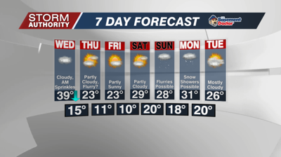
A cold front drops through the area on Wednesday, but it won't bring much moisture our way. A few sprinkles could pass through in the morning. It will be too warm for any freezing on the roads. A few flurries could show up late in the day, but accumulations are not expected. Temperature-wise, highs in the upper 30s in the morning, then falling to near freezing by mid-afternoon.
Dry and very cold weather is the story late week. Highs in the lower 20s, but overnight lows in the low teens to isolated single digits.
Our area just continues to be in the snow drought as systems bring snow mainly south of here. Kentucky is once again looking at some snowfall Wednesday night. The southeast and Mid-Atlantic could see a significant snowfall Friday into Saturday. The Canadian high pressure looks too powerful here for any concerns.


