

A mild and damp morning with scattered showers moving through. Scattered rain will continue this morning. The atmosphere will grow unstable this afternoon and allow for a scattering of thunderstorms. The best threat occurs from 2PM through around sunset (8PM). The stronger storms could produce large hail and damaging wind gusts, but there is also a chance for a brief, weak tornado or two. Not every location will see storms or severe weather, but have a way to receive weather alerts. These storms will be racing through, in some cases moving up to 50mph.
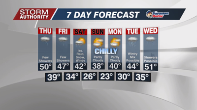
The weather looks cloudy and damp at times late week as a few more showers pinwheel through the region. Temperatures cool to near 50 Thursday, then only the 40s for highs Friday.
The upcoming weekend turns even colder, feeling more like winter. A disturbance will kick off a few rain and snow showers on Saturday. Highs fall to the upper 30s on Sunday despite some sunshine. Lows could even hit the upper teens in spots by Monday morning! Our next system will bring precipitation chances Tuesday and especially Wednesday as the cool air hangs tough.


