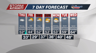


A substantial warm-up arrives today on gusty southerly winds. Expect temperatures to end up in the 70 to 75° range by 5pm! Outside of a random, brief shower, the area should remain dry with mostly cloudy skies. A wind advisory begins at noon with gusts up to 40mph expected later today.
The winds will ramp up a bit more overnight, gusts of 40 to 50mph can be expected. This could cause isolated power outages. Showers will hold off until after 11PM, with scattered showers continuing through sunrise on Thursday.
Just as fast as the warmth arrives today, the chill comes right back on Thursday! After a high of 52° at daybreak, temperatures will hover in the middle to upper 40s most of the day. Windy conditions continue with gusts up to 40mph. The day looks mainly dry outside of a spotty shower or two, but expect plenty of cloud cover.
Scattered light rain and snow showers are expected to roll in Thursday night through about sunrise on Friday. Above freezing air temperatures should only lead to wet roadways, but a few could wake up to a grassy accumulation Friday morning. Friday is a chilly day with highs in the low to mid 40s. Clouds will be stubborn, but some sunshine should return late in the day.
Most of the weekend looks dry with highs bouncing back slightly into the lower 50s. A weak disturbance looks to deliver a few light showers by Saturday evening and night. Temperatures try to trend near average for early to mid next week as shower chances increase.


