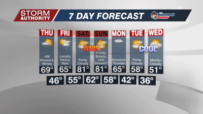


A cold and frosty morning, but temperatures recover back well into the 50s today. Clouds will gradually increase ahead of our next system with a few sprinkles possible this afternoon.
Temperatures actually hold in the 50s tonight as gusty southwest winds develop. After midnight into Thursday morning, some gusts of 30 to 40mph are expected. Much of the evening should be rain-free, but rain becomes likely after midnight.
Thursday starts windy and damp with scattered showers. We'll linger a chance of showers up through about noon. The second half of the day ends up very nice with skies becoming mostly sunny by mid to late afternoon. That sun allows temperatures to soar into the upper 60s, possibly hitting 70° in a few spots! Winds will not be as gusty later in the day.
Friday's forecast brings a threat of rain as a warm front lifts in. Some heavier downpours could occur with this activity, with the highest chance north of Lima. Placement of this boundary will make key differences in a mainly dry day vs. a rainy one.
Regardless of Friday, the confidence remains high for a summer-like and dry weekend! Sunshine and increasing humidity can be expected with highs reaching up to 81° both days. There might be a shower that sneaks in toward sunset Sunday, but most of that should hold off. A great weekend to make outdoor plans.
Showers return late Sunday night into Monday as a cold front passes. A thunderstorm or two is possible, but severe weather appears unlikely. It turns sharply cooler with temperatures well below normal by midweek. We are likely not finished talking about frost and freeze threats.


