


LIMA, OH (WLIO) - Our Storm Authority meteorologists use Doppler radar to watch the skies, but detailed radar coverage for Allen County is not the best. Meteorologist Conner Prince explains why this may have Governor Mike DeWine's attention and how this issue has implications for the area.

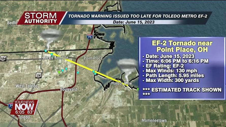
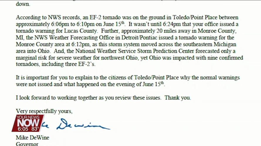
On June 15, 2023, a tornado outbreak impacted the Toledo and north-central Ohio region including a 130 mile-per-hour EF-2 tornado striking Point Place from 6:06 PM to 6:16 PM. This specific tornado garnered the attention of Governor DeWine because a tornado warning was not issued until 6:24 PM when the tornado already lifted. According to a letter written to the National Weather Service in Cleveland, Governor Mike DeWine requested information as to why warnings were not issued sooner.

A plausible to potentially likely answer to this is the lack of NWS radar coverage in northwestern Ohio, a problem that is very prevalent in Allen County and has the attention of the Allen County EMA director, Tom Berger.

"In Lima, Allen County, we're in between those three radar sites we were talking about. You have North Webster, Indiana, Cleveland, and Wilmington in southeast Ohio, are the three radar sites, and they kind of meet here in Allen County. So, if you kind of think about how a radar works, they kind of die off at the edge of their capacity," explained Tom Berger, Director of the Allen County EMA.
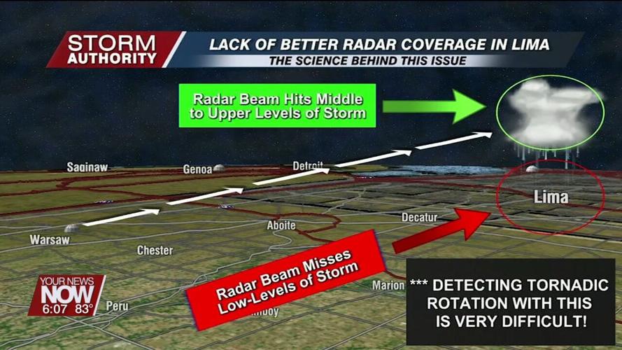
Let's dive into the science behind this problem. First, Lima is located between four NWS radar sites: Northern Indiana, Wilmington, Cleveland, and Detroit. When we measure each radar site, all of them are at least 90 miles away from Lima.
What consequences does this have for Allen County? To answer this question, we must understand how the radar beam works. The radar sends a beam out at an angle into the troposphere to scan for meteorological targets that send power back to the radar. The closer a location is to the radar site, the lower altitude the beam will scan. By the time the beam arrives to Lima, its height only allows the radar to scan the middle to upper levels of a thunderstorm and misses the lower levels. Thus, this means that low-level tornadic rotation may not be visible to the radar operator. This problem has already happened in our viewing area. On December 11, 2021, a high-end EF-1 tornado struck Hardin County near Ada without a tornado warning, and a solution to fix this problem may not be easy.
"To have those radar sites that are established by the National Weather Service, NOAA positions those sites. It costs a lot of money and not having, I guess, a particular site that we would be able to say yes, this is where a particular radar should go, and just from a local standpoint, we don't have a lot of say in how the National Weather Service works. Governor DeWine made it a point to write a letter to the National weather service. That definitely sheds light on the dead zone, kind of we have here in northwest Ohio," adds Berger.


