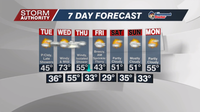


An impressive late March chill on this Monday morning with lows dipping into the upper 10s in several locations. Unseasonably cold, but far from a record. Today's record low is 1° set in 1934. Expect a good deal of sunshine today with afternoon highs in the middle 30s.
Expect one more frigid night tonight before changes arrive. Lows are forecast between 20-25° to start our Tuesday.
Tuesday is a decent day with temperatures reaching the middle 40s under partly cloudy skies.
Scattered, light showers are expected Tuesday evening and night as a warm front lifts into the area. Expect lows in the middle 30s during the evening, but rising well into the 40s by daybreak Wednesday.
The daylight hours Wednesday look dry and mainly cloudy as the warm front lifts north. Temperatures will skyrocket as winds ramp up. Temperatures will crack the 60s by midday, then eventually the 70°-75° range for afternoon highs! Winds gusts are likely to exceed 40mph by the afternoon.
Current guidance suggests wind gusts will hit 50mph Wednesday evening and night. The National Weather Service will likely issue wind alerts for our area as this period approaches. A weakening band of showers and storms will hit the area overnight. These showers could contain isolated pockets of wind that approach severe criteria. Rain totals are forecast to stay under a half-inch.
Expect gusty winds and plenty of clouds Thursday and Friday as chilly temperatures return.
Winds finally subside Friday night as the storm system pulls farther away. For now, we'll go with a dry weekend forecast with highs near 50°. There are signs of temperatures returning closer to average next week with 50s and perhaps a couple 60s.


