

Monday, January 17, 2022:
North and west Ohio escaped a major snowstorm that impacted the eastern half of the state overnight. Snow totals are coming in over a foot just east of Cleveland! That said, mother nature isn't leaving us out completely. A burst of snow showers is producing a light dusting this morning which could create some slippery travel. Expect a few snow showers through the day with highs in the low 30s. Travel impacts should become minimal for the afternoon.
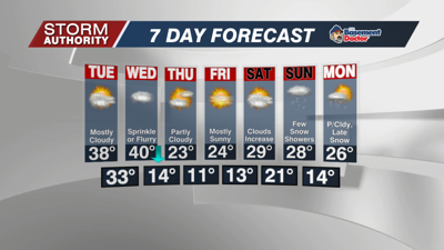
Tuesday is the best day of the week if you are making any outdoor plans. A southwest breeze allows temperatures to warm to the upper 30s. Clouds will be dominant but some sun will appear at times.
A cold front is set to arrive Wednesday. A few sprinkles or flurries are possible, but much of the day will be dry and cloudy. This is the warmest day of the week with highs near 40°, but those numbers start to drop during the afternoon in the 30s.
The late part of the week is dominated by a Canadian high pressure, meaning dry, sunny, and much colder weather. Get used to the cold - the long-range forecasts indicate below freezing highs for the rest of the month!!


