

The combination of ice along with a coating of snow has made everything quite slick this morning. As a result, many schools have either closed or delayed today. The slick travel will continue this morning, but increasing sunshine through the day will allow road conditions to improve. Afternoon temperatures top out in the upper 20s to near 30.
One forecast concern tonight will be gusty winds as an arctic front arrives. Gusts up to 40mph, along with the stress of ice on powerlines and trees may cause a few power outages. Temperatures will warm to around 30°, but start to sharply fall after 4AM from the 20s to the teens by sunrise.
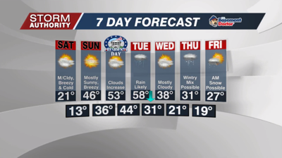
A frigid and blustery day on Saturday as wind chills fall below 0° for the morning hours. Those winds will gradually ease up, but temperatures will hover in the upper teens to low 20s with mostly cloudy skies.
Sunday brings a dramatic temperature swing our way. The day starts with temperatures around 13°, then soaring to 46° later in the day under bright sunshine and a breezy southwest wind.
The extended forecast shows two storm systems next week. The first one brings rain Monday night through Tuesday night, perhaps ending as a mix. Mild temperatures are expected through Tuesday, then a much colder pattern mid to late week. A secondary storm may impact the area by Thursday/Friday. Early data shows the possibility of mixed wintry precipitation, so this will be a system to monitor.


