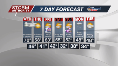


Tuesday, April 12, 2022: A foggy start to the day with cool temperatures. The fog will lift mid to late morning, giving way to a gorgeous spring day. Highs should reach the upper 60s with some sunshine around.
Expect a pleasant night with temperatures holding steady in the lower 60s. A stray shower or two is possible, but most areas will remain dry.
Active weather for Wednesday with numerous showers and storms rolling in throughout the day. A threat for severe storms will increase during the night as a strong cold front arrives. Best threat looks to be after 10PM through about 2AM. Damaging wind is the highest concern. Isolated tornadoes are possible too, but it's important to remember that straight-line wind can produce even more damage than a weak tornado.
DOWNLOAD THE YNN WEATHER APP! This is a great option to receive alerts down to your exact location. Inside the app, go to settings and select "Weather Notification Types." Under the severe category, be sure the severe thunderstorm and tornado WARNING options are selected. From there, go back to settings and select "Notification Sounds." Make sure that is turned ON. You can also choose what type of sound activates on your device when the alert is issued.
Once the storm system passes, expect sunshine, breezy winds, and cooler temperatures Thursday and Friday. While numbers will still run close to normal, it will turn progressively cooler for the weekend through early next week.


