

Tuesday, April 19, 2022: A winter-like system on Monday dropped 1" of slushy snow on grassy and elevated surfaces. This puts our season total at 14.7". Spring snows have been common the past few years. 4.3" fell last year on April 20th-21st. In 2020, the area had sticking snow on April 17th.
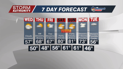
Another chilly day on tap with breezy winds making it feel colder. Highs are expected to push toward the middle 40s with mostly cloudy skies. A few rain and snow showers are expected, especially prior to 2PM. More breaks in the clouds will develop toward the evening.
High pressure will relax our winds and clear the skies out tonight. This will allow for temperatures below the freezing mark by Wednesday morning. Areas of frost can be expected.
Expect a decent recovery in temperatures Wednesday. Southerly winds will turn breezy late in the day as temperatures reach the middle and upper 50s.
A frontal system will bring rain showers Wednesday night through Thursday morning. Rain totals should run around 0.2". Showers should taper off by mid to late morning. Dry weather and some sun return for Thursday afternoon as temperatures reach the upper 60s.
A warm front approaches Friday and will give us mostly cloudy skies. We'll have the risk of a few scattered showers or a thunderstorm as it moves in, but data still greatly disagrees on coverage of rain. This front lifts north of the area this weekend and ushers in the warmest air of the season. Highs both days should run around 80° along with increasing humidity. It will feel more like June. Both days look dry with some sunshine.


