

Our Thursday is starting off with some sunshine and a few spotty showers. Clouds will become more dominant by afternoon with isolated showers rotating through the area. Expect highs in the lower 50s.
Most of any pop-up showers will fade away after sunset. It will turn colder overnight with lows in the middle 30s.
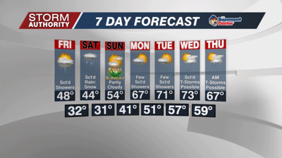
Friday is a chilly day for April with mostly cloudy skies. A scattering of showers will work through the area, with a few snowflakes mixing in early. By afternoon, a random lightning bolt along with graupel (snow pellets) could occur in the heavier showers due to a intense pocket of cold air aloft combined with the (relatively) warmer temperature at the surface.
Saturday is a good weather day to stay inside with hot chocolate. There will likely be a few passing snow showers mixed with rain. Highs only hit the lower to middle 40s. Most of the activity should exit by late afternoon. Much better conditions for Sunday with some sunshine and not as cold. Temperatures will recover to the lower/middle 50s.
A stretch of much warmer weather arrives next week. Highs in the 60s and 70s can be expected. The pattern also brings a daily chance of rain, but these will be scattered with plenty of dry time. Just beyond the 7-day, signals point to a notable cooling trend for Easter weekend.


