

Cloud cover was a saving grace for all of the blooming vegetation as temperatures stayed above freezing overnight. There are no additional frost and freeze concerns within the next week.
Skies will tend to be mostly cloudy today, but we'll see some sun peek through. A few sprinkles are possible, but a majority of the area will stay dry. Highs are expected to hit the middle 50s. Lows tonight drop to around 40°.
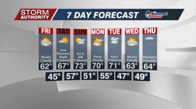
Friday will bring a decent end to the week. Highs will be noticeably milder with afternoon highs in the lower half of the 60s. Skies will be mostly cloudy, but it should be a dry day.
While rain chances pick up this weekend, we are expecting a lot of dry time on both days with comfortable temperatures. A warm front approaches Saturday and brings a few scattered showers. This initial surge of showers will fall apart during the afternoon and allow temperatures to climb into the upper 60s for the high. The atmosphere grows more humid Saturday night and conducive for scattered showers and storms as a weakening cold front moves in. There is a marginal severe risk that clips the western edges of our counties that border Indiana. Scattered storms are forecast to weaken as they roll through overnight through Sunday morning. A drier slot of air should allow for some sunshine and a nice rebound into the lower to mid 70s Sunday afternoon!
The data shows strong agreement on two storm systems rolling through Ohio next week. We'll enjoy a dry and warm day Monday, but a system will spread widespread rainfall our way for Tuesday. We'll need to monitor the threat of storms and a possibility of stronger storms depending on the track. Another break in activity Wednesday before our next storm brings rain toward Thursday.


