

LIMA, OH (WLIO) - El Niño is back for the first time in four years, and it's likely to cause more extreme weather across the country. Meteorologist Nathan Kitchens discusses what that might mean for our area.

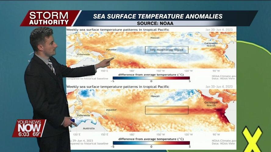
Changes are among us! The National Oceanic and Atmospheric Administration (NOAA) officially declared an El Niño climate pattern has developed. We started the year with La Niña conditions, associated with cooler-than-normal water temperatures in the eastern and central Equatorial Pacific. The pattern has taken a dramatic swing to El Niño conditions, represented by warmer-than-normal waters in this area.

"After the triple dip La Niña that everyone talked about, I think most folks knew that the writing was on the wall that we probably weren't going to see another La Niña and perhaps El Niño was the answer to that," said Kyle Brown, National Weather Service Northern Indiana.

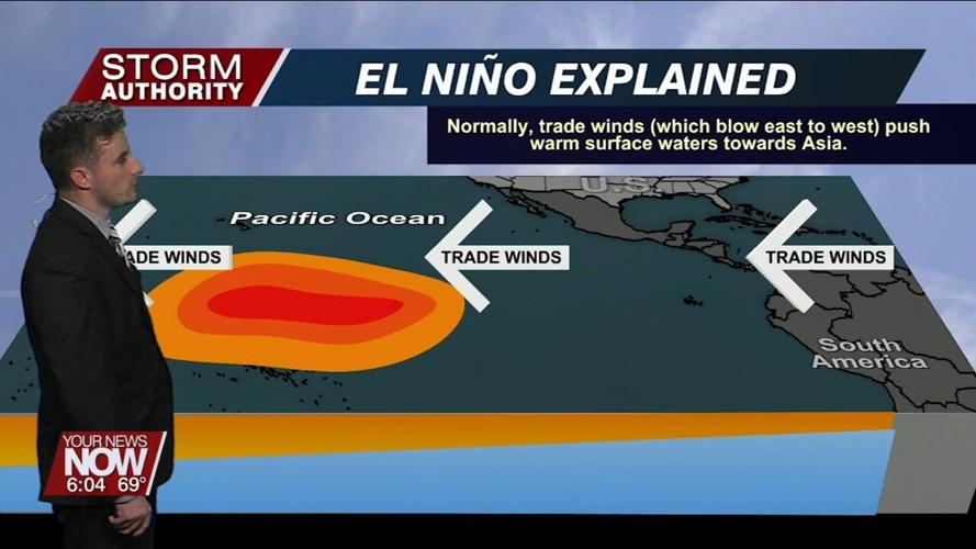
How does an El Niño develop? It has to do with the trade winds in the pacific ocean near the equator. When those easterly winds slow and shift directions, that pushes warmer waters east from Asia toward the west coast of South America. This results in warming the air masses above it, impacting the jet stream position & strength. This change means shifts in temperature and precipitation conditions on a global scale.
The meteorologists at NOAA give the current El Niño a 56% chance of developing into a strong event. This tells us that El Niño is likely to play a significant role in weather patterns. El Niño episodes tend to have the most noticeable impacts on weather during the winter season. In a typical El Niño, areas from southern California through the gulf coast will experience wetter and cooler conditions compared to normal. On the flip side, the northern U.S. is usually milder and drier thanks to a split jet stream, limiting moisture in these areas.
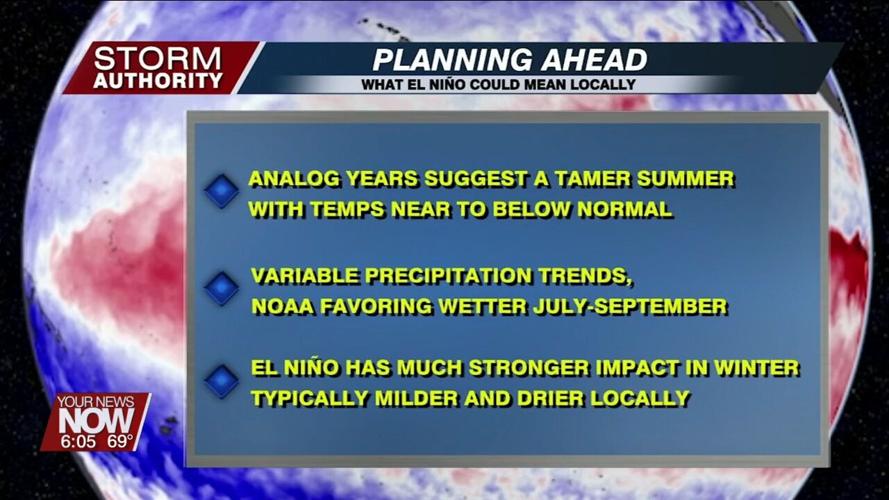
For our local area, we looked at analog years that featured a developing El Niño during the summer. We found that two-thirds of those years brought cooler-than-normal conditions during the summer season. Based on recent trends, it would seem realistic that cooler conditions could be a reality for summer 2023. Precipitation trends in the summer were highly variable with no real signal to follow. How about the winter? The signal becomes stronger for milder-than-normal temperatures and below-normal moisture in our area. This could be welcome news for another tame winter, but the forecast is far from etched in stone. There are many factors beyond El Niño that are unpredictable this far in advance.
"This sounds really wishy-washy and the reason for that is there are other circulations and other teleconnections that are at play as well. That's why we start with El Niño to give us this idea of what our broader winter weather pattern might look like. As we get closer, we have time to fine-tune the forecast and the expectations," added Brown.


