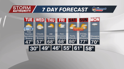


Monday, April 18, 2022: A cold start to the week with the threat of April snow showers. We are tracking a system that has already dropped enough snow to cover the ground in Indianapolis, and that same activity is pushing our way. The period from mid-morning to just after noon will bring our best chance. Once the snow pulls away by 1/2PM, any accumulation will quickly vanish. A lull in precipitation will be replaced by a few scattered rain showers late this afternoon into the evening. Highs will top out in the low to mid 40s.
The winds turn breezy tonight on the backside of this system. Scattered showers will taper off later this evening with only a spotty rain or snow shower overnight. Lows will fall to the lower and middle 30s, hovering just barely above freezing.
A chilly northwest wind will keep temperatures in the 40s on Tuesday, but the day is drier with only a few sprinkles and flurries. Skies should start to brighten up later in the afternoon for some sun.
Much warmer air arrives later this week. The 50s are back Wednesday. By Thursday and Friday afternoons, we won't be far from 70° A couple of very warm days look to time out perfectly for those weekend plans. Highs of 75° to 80° are expected Saturday and Sunday.
How about rain chances? A front will give us some light rain overnight Wednesday into the morning of Thursday. Skies turn partially sunny later on with drier air for the afternoon. On Friday, a warm front could give us a few showers and thunderstorms. We look dry Saturday through much of Sunday, then rain chances return along a cold front on Monday of next week.


