

A mild and dry start to our Wednesday with a few patches of fog. Expect scattered showers to arrive just before the noon hour, with those scattered showers diminishing by 4 to 5pm. Expect temperatures to hover in the 50s.
Expect a dry overnight with partly cloudy skies. Fog should not be an issue due to a steady breeze and a drier air mass. Lows will drop to around 40.
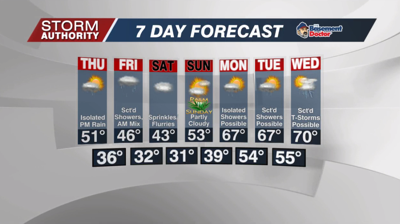
Thursday brings partly to mostly cloudy skies. Much of the day will remain dry, but expect isolated showers to pop-up for the afternoon. Highs will reach near or just above 50°.
A gloomy, damp, and chilly day expected on Friday with scattered to numerous light showers around. Some snowflakes could mix in during the morning. Temperatures will reach the middle 40s. Breezy winds will make it feel like the 30s.
A few snow and rain mixed showers linger Friday night into the day Saturday. The first half of the weekend stays gloomy and cold with lower 40s. Expect improvements on Sunday with some sunshine returning. Highs recover back into the 50s.
A stretch of mild temperatures is expected next Monday through Thursday. Highs deep into the 60s. Unfortunately, several chances of rain will get thrown our way as early as Monday. A strong cold front is expected to push in toward next Thursday, possibly bringing storms followed by a big cool-down for Easter weekend.


