

Tuesday, April 5, 2022:
A cool start to the day with partly cloudy skies and a few areas of fog. Today is shaping up to be one of the better days for outdoor plans as highs reach the 60s. We'll see some morning sun followed by mostly cloudy skies. The rain chances are slowing down until after 4PM, with the best chance during the early evening for a few brief showers.
After a few evening showers, the night looks mainly dry with fog possible after midnight. Expect milder temperatures in the upper 40s.
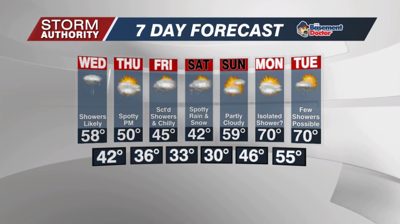
A cold front will bring a period of showers Wednesday, mainly from mid-morning to early/mid-afternoon. Most of the rain exits by 4PM with lots of sunshine arriving for the evening. Highs will be a bit cooler in the upper 50s.
Thursday looks mostly dry and breezy with spotty rain coverage for the afternoon. Expect cool temperatures around 50°.
Higher chances for scattered, light rain return Friday. While it won't rain the whole day, it will be rather gloomy and cold with highs only in the middle 40s. By Friday night, a few snow showers are likely.
The gloomy and cold weather continues Saturday. We could see a few rain or snow showers, mainly in the morning. Highs only hit the lower 40s.
Sunday looks much, much better!! Highs could approach 60° with the return of sunshine.
LONGER RANGE: A stretch of warm temperatures is looking to arrive early next week with a few days of 70°+ possible. The pattern does remain active with several rain chances showing up during the week. A cooling trend back to below normal is showing up toward Easter weekend. Keep in mind, even "cooler than normal" likely still equates to highs in the 50s.


