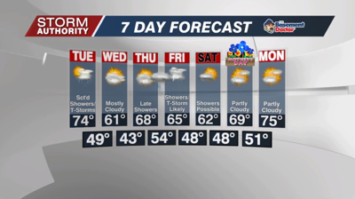


The week starts off dry, but we have two storm systems set to move through the area over the next week bringing rain and storm chances.
Expect lots of lingering clouds for Lima and points north today, but skies will be sunnier to the south. With time, we should see a decrease in clouds through the afternoon. Highs will range from upper 50s north to upper 60s south, around 64° in Lima.
After a dry evening, scattered showers are forecast to develop after midnight, with better chances as we approach daybreak. Expect a mild night in the 50s.
Tuesday starts off wet with showers and an isolated storm. The bulk of the rain lifts north by late morning with gaps of dry weather. More scattered showers and the risk of thunderstorms for the afternoon. The track of the low is KEY in determining our severe weather chances. As of now, a marginal severe risk is in place for Lima and point southeast with wind and hail the main threats, but flooding is also a threat. While some spots see as little as 0.25" of rain, other spots could get hammered with the up potential at 2-3" in the heaviest storms. Highs will generally range from the upper 60s to lower 70s, but a few drier spots could reach mid 70s.
Expect dry weather to return on Wednesday and most of Thursday with more clouds than sunshine. Highs around 60° Wednesday, but 65 to 70° Thursday.
Our next system brings showers late in the day Thursday, with highest chances Thursday night through Friday night. The area could see heavy rainfall along with embedded storms.
The late week system is a slow-mover as it is largely cut off from the jet stream. It appears some scattered rain could linger for our Saturday, but data continues to show very nice weather by Mother's Day with some sun and pleasant temperatures. Timing/duration of this system will change in future updates, so check back through the week.


