

A mild, windy, and damp start to the day with sprinkles and drizzle around. Any showers should end around noon. Clouds give way to plenty of sunshine by the middle to late afternoon. Highs will top out between 65 and 70° with a breezy west wind.
Expect a quiet night as winds go calm. A patch or two of fog could form, but most of that will develop south of our area. Lows in the lower to middle 40s.
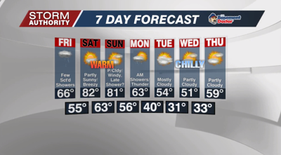
Friday brings mostly cloudy skies and another shower threat as a warm front approaches. The trends suggest the rain is scattered at best, with the greater focus over southern Michigan. Highs should top out in the 60s.
The weekend continues to look more like summer with near record heat. Highs will top out in the low 80s, with a few warmer spots making a run at mid 80s, especially Saturday. The only "chance" of rain would be toward sunset Sunday as a cold front approaches, otherwise expect dry and windy weather. Gusts up to 40mph are possible Sunday.
It continues to look rather cool next week. Highs for several days will run in the 50s. There is a rather strong signal for a freeze by Wednesday morning of next week. Keep this in mind as vegetation is going to rapidly sprout with the warmth over the next few days.


