

Wednesday, April 13, 2022: The air is very mild this morning as temperatures hold in the middle 60s. After a dry start, showers will develop and spread into the area later this morning (mainly after 10am), and continue off and on through the afternoon along with embedded thunder. This round of activity should not be severe.
The showers may taper some in coverage late in the afternoon, then we'll watch the evening into the overnight for a few strong to severe storms. Overall, the clouds and showers today will act to diminish the "fuel" for severe weather tonight. That said, the wind energy aloft is strong and the passing showers and storms could still pack rather gusty winds. The tornado threat is low, but not zero. An exact timing is uncertain as we'll likely have a few "waves" of activity move in throughout the evening. Although thunder chances decrease after midnight, a wave of showers along the cold front (2-4am) could still pack strong wind gusts. The core of the severe weather occurs southwest of here toward the mid-Mississippi River Valley, where a significant severe weather event is expected.
After spending most of the night in the 60s, a very sharp drop will occur from about 3AM to sunrise from the 60s to the lower 40s.
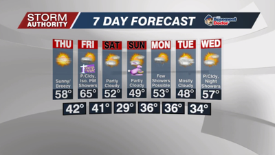
Thursday is much calmer and brighter with lots of sunshine. Highs will top out in the upper 50s. Expect a breezy day with gusts around 35 mph from the southwest.
Overall, it's a relatively dry pattern through Easter! We do see a cold front passing Friday evening with a few light showers. Temperatures will warm ahead of the front well into the 60s for Good Friday, but drop to near 50° Saturday and Sunday. A freeze is possible Sunday morning with lows in the upper 20s. With the growing season starting, keep this in mind for blooming plants.
A cool pattern continues much of next week, with the coolest air on Monday and Tuesday. A change toward warmer weather is possible just beyond the 7-day forecast.


