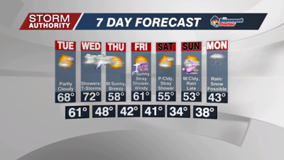


Monday, April 11, 2022: After a few thundershowers early, a break in the rain is expected for most of the morning. Scattered showers can be expected to build this afternoon with numerous rain activity for the evening hours. A few heavy pockets of rain along with lightning will be a possibility. Expect highs in the 60s. Lows tonight drop into the 40s as rain tapers off after midnight.
Tuesday looks great!! We are now calling for a dry day with partly cloudy skies. Highs should top out in the upper 60s. There could be a few patches of fog in the morning. Tuesday night looks warm! Our low won't even fall below 60° as a warm front passes the area.
Wednesday is an unsettled weather day with scattered to numerous showers and storms around. Winds will become gusty as well, even outside any storms. While an isolated stronger storm is possible during the daytime, it is the overnight period that brings our main severe threat. A squall line may produce strong enough winds to produce some damage Wednesday night. The greatest threat is after 8PM Wednesday through about 5AM Thursday. Exact timing will be narrowed down in future forecasts.
Once the cold front passes, mainly sunny and windy weather arrives late week. Gusts look to reach over 35mph Thursday, then possibly reaching 40 to 50 mph on Friday. While a stray shower is possible Friday, dry weather is anticipated overall.
Differences in forecast models lead to somewhat lower confidence for Easter weekend. It does look rather cool with highs in the lower to mid 50s. The forecast is for mainly dry skies right now outside of a couple stray showers on Saturday. A better chance of rain or even wet snow could arrive toward Monday as even chillier air arrives. Temperatures for much of next week look significantly cooler than normal.


