

Thursday, April 14, 2022: A much cooler and breezy morning as clouds give way to sunshine. A beautiful blue sky will be with us this afternoon, but it will be windy as temperatures stay cool. A wind advisory will go into effect after 12PM through 8PM. Gusts late this afternoon could hit 40 to 45 mph. Temperatures will reach the upper 50s for the daytime high.
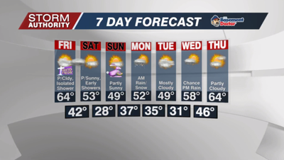
Our Good Friday looks a little warmer as highs reach the lower to middle 60s. Breezy winds will be the story again. In fact, we could reach 40mph gusts by the afternoon. There could be an isolated shower, but much of the day will be dry.
A greater chance for light showers Friday night as a cold front moves through. These showers could linger up to 8/9AM Saturday, then skies will brighten up for lots of sunshine by the afternoon. Highs Saturday will be roughly 10° cooler than Friday, ranging from 50 to 55°.
Easter Sunday looks sunny and chilly! It will be a frosty and cold morning with lows in the upper 20s. Our afternoon high will struggle to hit 50°, but at least the wind won't be too breezy.
A much cooler than normal temperature trend continues for the early part of next week. A system will give us a threat of light rain Monday morning, possibly mixing with a few snowflakes. Tuesday looks quiet and cool, then our next front delivers the chance of showers later Wednesday into Wednesday night. It does appear temperatures recover closer to normal later in the week.



